
Off the beaten path outside of the sleepy town of Estacada lies a massive yet unassuming State Park. Near to, yet somehow a world away from, the hustle and bustle of Portland,
Milo McIver Park may seem, at first glance, to be nothing more than a place to stretch your legs or spend a quick night on your way to the Ripplebrook area. However, a closer investigation may reveal much more about this gem than meets the eye. The park not only offers access to the wild Clackamas River and the scenic Estacada Lake, it also boasts a hiker/biker camp, a fish hatchery, two disc-golf courses, and miles upon miles of hiking and equestrian trails.


Dropping down from the park entrance, the road splits into two directions, each accessing a different section of the park. Hang a left to access the Riverbend day-use area, or a right to find the campground and the Riverside day-use area. Riverbend offers one undeveloped boat ramp at its far end, but this part of the park is mainly popular with disc-golfers. For those unfamiliar with the sport, it is a cross between the classic sport of golf and the picnic pastime of tossing the frisbee. Players take turns tossing their discs from the "tee" (a well-marked concrete pad) towards the "hole" (an elevated cage to catch the discs). As mentioned, Riverbend boasts two courses: a smooth 9-hole course and a more challenging and technical 18-hole course. You will encounter the 18-hole course as you first enter this section of the park, with the 9-hole course farther along the road after some group picnic areas. Discs are available to rent or buy from the park office.

This section of the park was actually the site of a fascinating chapter of Oregon's history. In the year 1970, with the Vietnam War at its peak, Portland was set to host an American Legion convention led by none other than then-President Richard Nixon. With rumors of anti-war protests set to break out downtown, Governor Tom McCall decided to create a diversion in the form of Vortex I, a Woodstock-inspired rock festival held at Milo McIver State Park. The diversion was a success, due in part to Nixon's last-minute cancellation, and approximately 35,000 people attended the free, state-sponsored music festival. For further reading, click
here.


Heading towards the other day-use area, watch for the Milo McIver Memorial Viewpoint. A plaque tells the story of Milo K. McIver, a long-time member of the Oregon Highway Commission and supporter of Oregon's State Parks. As of this posting (June 2017) the viewpoint is currently under construction, but look forward to uninterrupted views soon. Shortly past the viewpoint, watch for a spacious leash-free dog area, the park office, and an equestrian staging area before descending the bluff and heading towards the river. A dirt road off to your right will lead to the Steelhead and Chinook group camps, as well as the spacious hiker/biker camp where the author spent his stay. There are only two private tent pads at this camp, but the nearby field is fair game as well and is quite private. Amenities include a covered eating area, fire ring, tire pump/bike repair station (including commonly required tools), and lockers complete with solar-powered USB phone chargers (inquire with camp host for padlocks).

Farther along the main road, watch for the campground off to your right. There is one main loop of 44 full-hookup RV sites (including one ADA-accessible site) and a smaller loop of nine tent-only sites. The campground is a simple affair, but hot showers, flush toilets, and an RV dump site are provided. Past the campground on the main road, watch on your right for a dirt track heading to the River Mill Dam viewpoint and a developed boat ramp on Estacada Lake. The historic dam creates a beautiful cascade into the river below, and the resulting lake on the far side is the picture of serenity. Fish from the accessible fishing dock, bring a boat to explore in, or
rent a kayak and take a tour on any Sunday or Wednesday from June to September.

Nearing the end of our main road, we enter Riverside day-use area. Here we find our third and final boat ramp. This well-developed boat ramp with access to the Clackamas is often used to form a loop with the Riverbend day use area; put in at Riverside and float the Class 2 rapids through the twists and turns of the river before taking out at Riverbend and driving back to camp. Past the boat ramp, enter into a final picnic area. As the parking lot loops around and turns back, watch for a road off to the right leading to the Clackamas Fish Hatchery. The tanks were drained during my stay as the Hatchery was in its off season, but it is open to the public and will be a bustle of activity later in the year.

For those wishing to explore the park on foot, over fourteen miles of hiking trails intertwine and intersect throughout the park, forming scenic loops catered to any skill level. These trails are at times somewhat ambiguous, as trail signage leaves something to be desired and trail maps often disagree as to where trails actually run.
This state park map,, included in the official park brochure, gives the most complete and up-to-date information, but even it leaves something to be desired. Equestrians are welcome on the trails near the campground and Riverside day-use area, with a staging area located near the park office. There is currently no overnight horse camping available, but a horse camp and additional trails are currently in planning. For now, the staging area offers a hitching rail, an outdoor arena, and an ADA-accessible mounting ramp.
 |
| Maple Ridge Trail |
 |
| Vortex "Loop" Trail |
Starting at the far end of the Riverbend day-use area, pick up the Maple Ridge Trail across from the rustic boat ramp. This trail climbs through dense forests and marshy swamplands on the bluff behind the park. Return on the Cedar Knoll Trail to make a 1.5 mile loop, or continue on the Maple Ridge Trail and connect to the Riverbend Trail to explore this end of the park further. Follow the Riverbend trail through the forest and along the river for an additional 1.7 miles to connect back with the parking lot you started from. Near the Kingfisher group camp, watch for an intersection of the Riverbend and Vortex Loop trails. The Vortex Loop Trail is quite pretty, following along the forests and fields where campers lodged during the Vortex I music festival. Ironically, however, at the time of this posting it is not a loop. Trails in the section are still under development, so it is safe to assume that the spurs will someday connect, but at this time they diverge and lead to other parts of the park. The west spur is under development will eventually connect to the Milo McIver Memorial Viewpoint and the Riverside Day-use area, and the east spur leads along the bottom of the bluff on a trail not marked on most maps and connects to the Rivermill Trail.
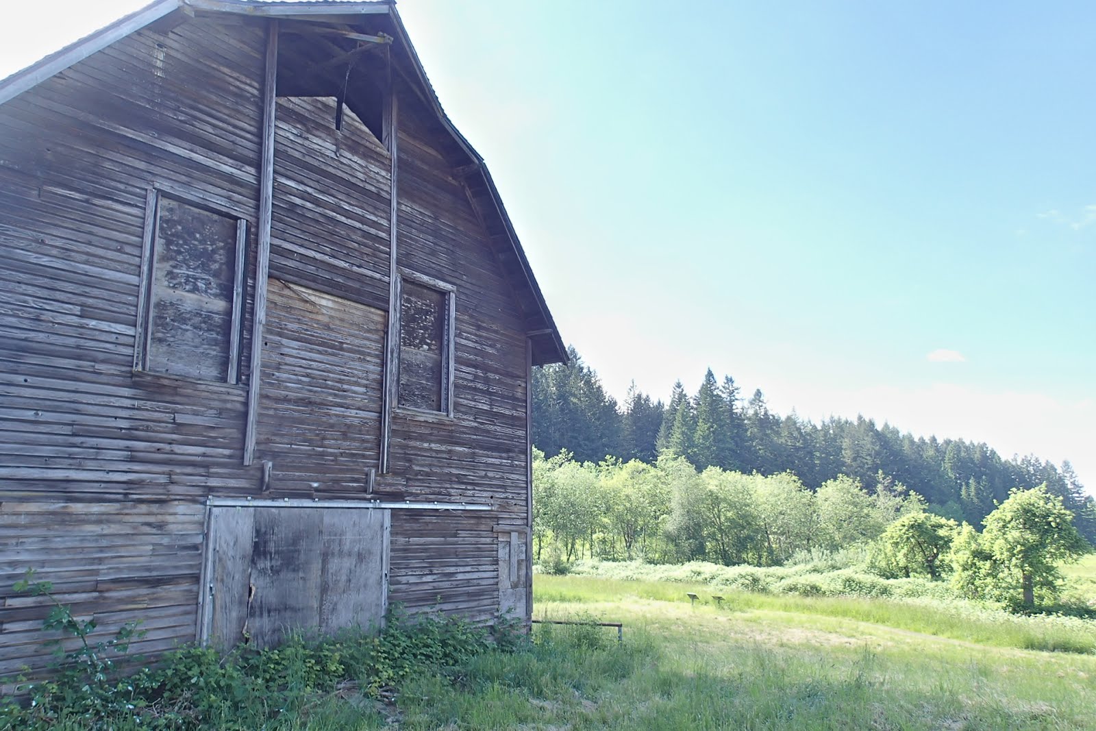
 |
| Barn on the Bat Trail |

The Rivermill Trail forms a four-mile loop around the campground and Riverside day-use area. Pick up the trail at the east end of the campground and head south up the bluff. Around one mile in, meet up with the Bat Trail, a 0.8 mile loop around a picturesque meadow and venerable old barn, which houses a community of Townsend's big-eared bat. Equestrians can pick up this loop trail from the staging area and take advantage of the loop's training stations, which are a series of obstacles for horses such as logs, gates, and bridges. Rivermill Trail continues on for a mile and a half before passing between the campground and fish hatchery. The 0.2 mile Dog Creek Trail runs around the hatchery and offers views of Dog Creek, the Clackamas River, and the nation's second largest yew tree (oddly specific, but at least they're proud). Rivermill Trail continues on for another 0.7 miles, running past the river and the River Mill Dam before ending back at the campground.


To find the park from Portland, take Highway 224 east to Springwater Road (about 4.4 miles from the junction with I-205). Follow Springwater Road for approximately 9.6 miles to find the entrance to the park. A special note for cyclists: to cut out some of the hills, take the Springwater Trail east out of Portland until it ends in the town of Boring. Follow Richey Road (across Highway 212 from the end of the Springwater) and turn right on Kelso road. Shortly afterward, turn left on Amisigger Road and follow it several miles until it ends at Highway 211/224, then follow the highway through Estacada. Cross the river on Highway 211 and take an immediate right onto River Lake Road. This private drive dead ends, but an inactive forest service road remains open to cyclists, pedestrians, and equestrians. Please be courteous and be willing to walk your bike as some horses have never seen a bicycle before and you will give them quite a fright! This road enters the park near the Estacada Lake boat ramp and can be a great way of avoiding some hills. However you get there and whatever you do there, Milo McIver Park is much more than a stop along the way. So grab some hiking shoes, a horse, or a frisbee and come enjoy this beautiful riverside park. Or bring all three, who are we to judge?
 |
| Secluded spot in the Hiker/Biker camp |
 |
| One of the nine tent-only sites |
 |
| Upper section of the River Mill Dam |
 |
| Estacada Lake |
 |
| Clackamas Fish Hatchery (currently drained) |
 |
| Clackamas River |


 |
| Bat Trail |


 |
| Clackamas River |

 |
| Abandoned water tank |


 This classic Oregon road trip leaves the city behind, passes through the dramatic Columbia River Gorge, winds through high desert country, and returns through the Cascade Mountains. The basic loop is only around 225 miles and could even be done in a day, but it offers numerous opportunities for exploratory side trips and deserves a multi-day investment. Be sure to bring food, water, and a detailed map, as some stretches offer few amenities.


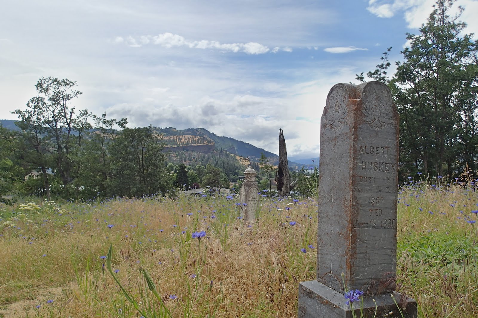 Continue east along the river to Exit 69 and the little town of Mosier, first settled in 1854. There are several historic buildings here, including the still-functioning schoolhouse built in 1920 and the cutest public library we have ever seen. This is a fun town to explore, with well-preserved buildings and a few historic mysteries. Park near the train tracks for the Mosier Plateau hike; those who are able to negotiate the steep and dusty trail should at least go up the hill and find the scenic, wildflower-spangled Pioneer Cemetery.


